Tag Archives: Oceans

Category
Format
image
gallery
video

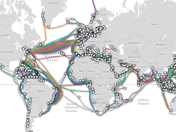
The Undersea Cable Network

Tweet about this on TwitterPin on PinterestShare on LinkedInEmail this to someoneShare on Facebook
Everything about telecommunications feels so instantaneous and global that most of us just assume satellites are the magic network that holds it all together. Sure, they stitch together vital parts of our networks but when you need to move heaps of data around the globe, it’s going underwater. Over 400 international cables stretch more than 550,000 miles (885.139 km) across the ocean floor and carry unfathomable amounts of data. The longest cable is SEA-ME-WE3, and moves data at roughly 575 gigabytes per second between 34 countries from Germany to Australia. SubmarineCableMap.com has an interactive map that lets you dive into the specs of every cable out there and explore how they connect the far reaches of the planet. Business Insider made this cinematic view of the same data which sprinkles in some fun facts along the way.  And if you really want to get into the far corners of possibility, Gizmodo published a fun read back in 2012 about how one might theoretically be able to destroy the internet in which the cable network plays an important role.

Inverted economics of fishing the high seas

Tweet about this on TwitterPin on PinterestShare on LinkedInEmail this to someoneShare on Facebook
Using satellite imagery and machine learning, we can now monitor global fishing fleets in near real time, including the previously opaque world of fishing on the high seas. It’s estimated that without government subsidies, over half of this $8 Billion market would be unprofitable, including all deep-sea trawling, a perennial culprit of extensive ecosystem damage. The high seas — marine waters that fall outside national jurisdiction — cover 43% of the Earth’s surface and the fishing of its depths is dominated by 5 countries: China, Taiwan, Japan, South Korea, Spain.  In their paper “The economics of fishing the high seas“, the authors dive into the technical details of their economic analysis and while it can get pretty dry in spots, the use of satellite imagery with advance machine learning is an incredible application of technology.